World Political National Geographic 1100 x 780mm (Pacific Centred) Laminated Wall Map with Hang Rails
World Political National Geographic 1100 x 780mm (Pacific Centred) Laminated Wall Map with Hang Rails
🌏 World Political Wall Map – Pacific Centred
By National Geographic – Laminated with Wooden Hang Rails
Size: 1100 mm (W) × 780 mm (H) | Scale: 1:36,384,000
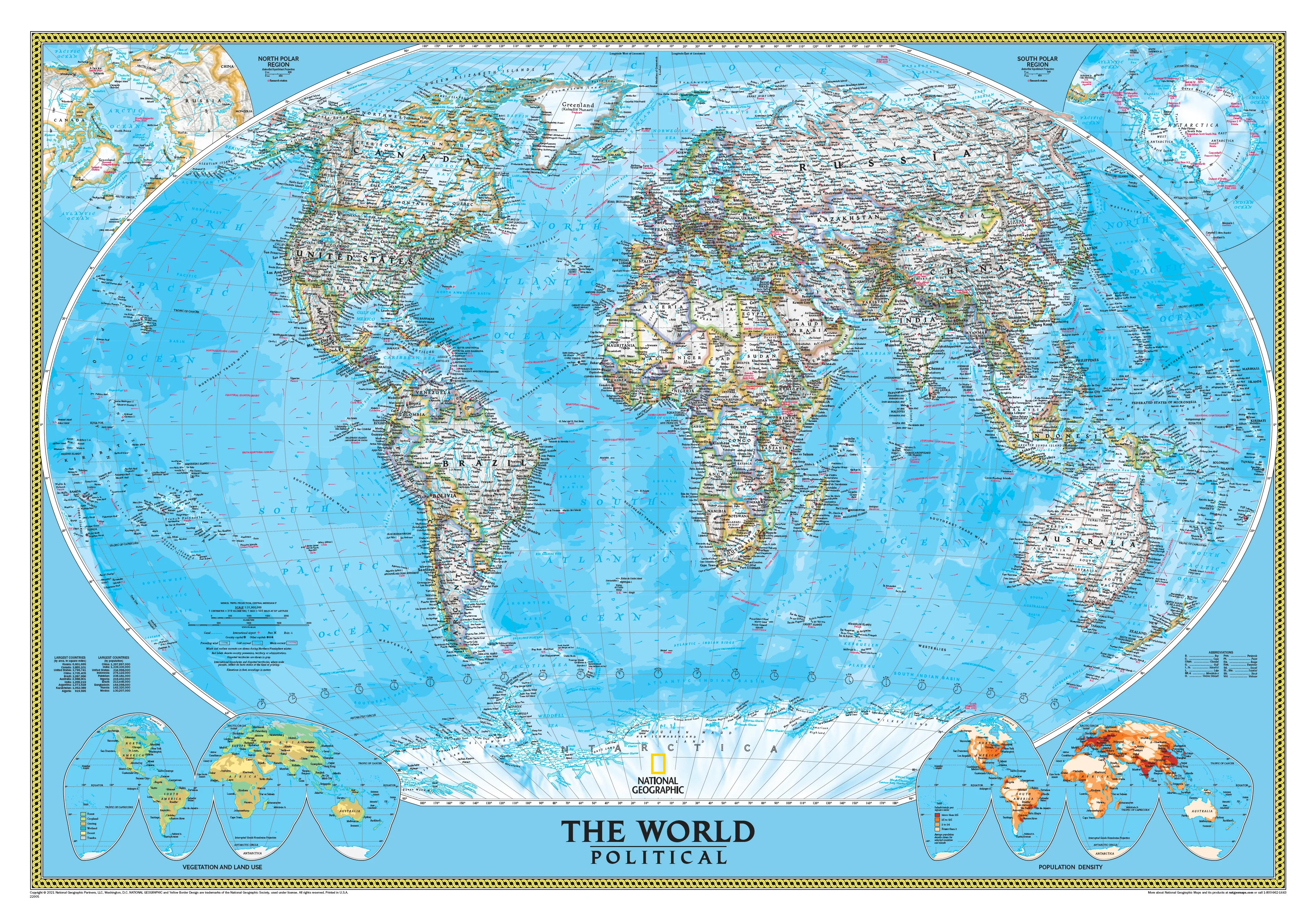
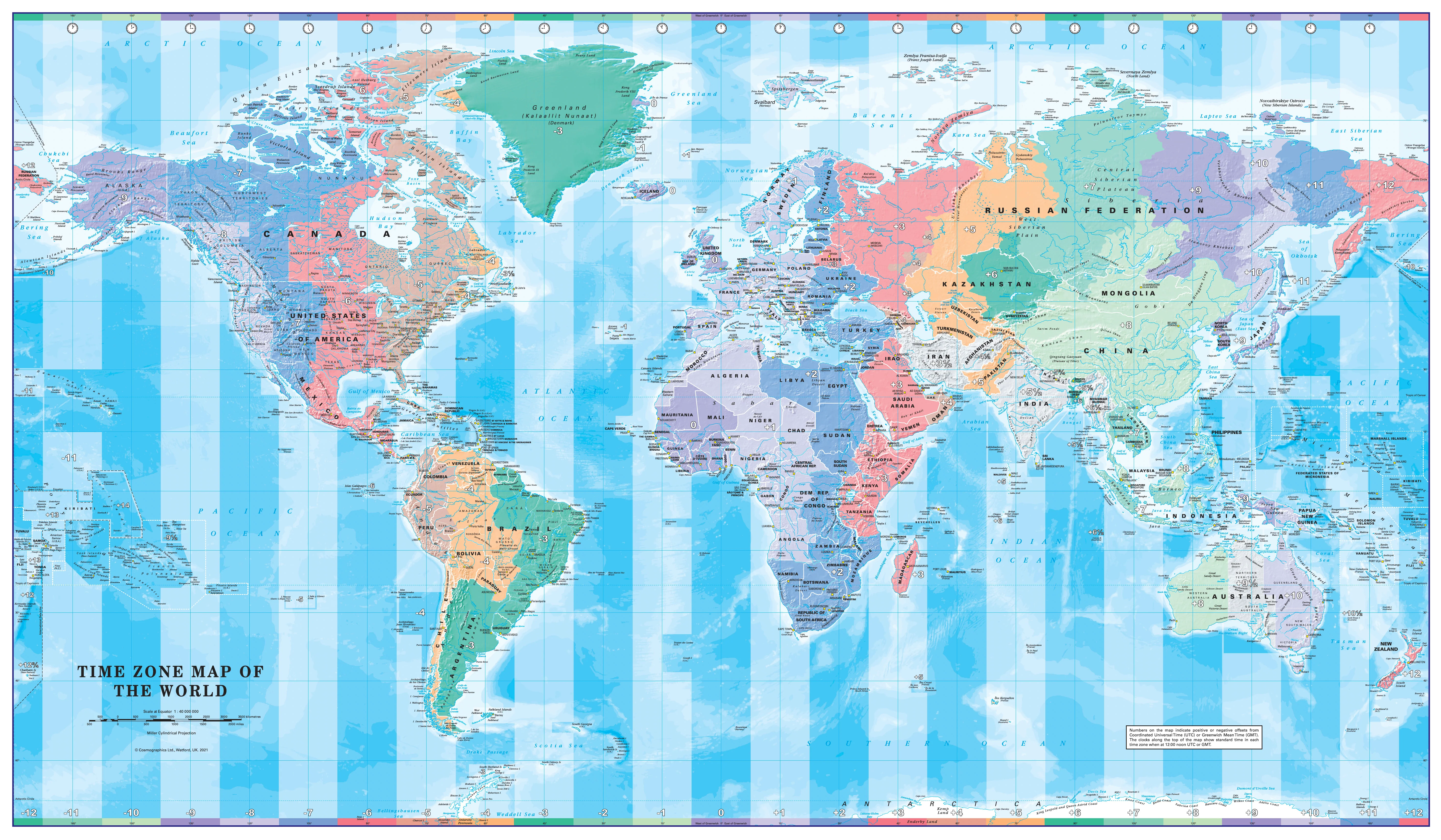
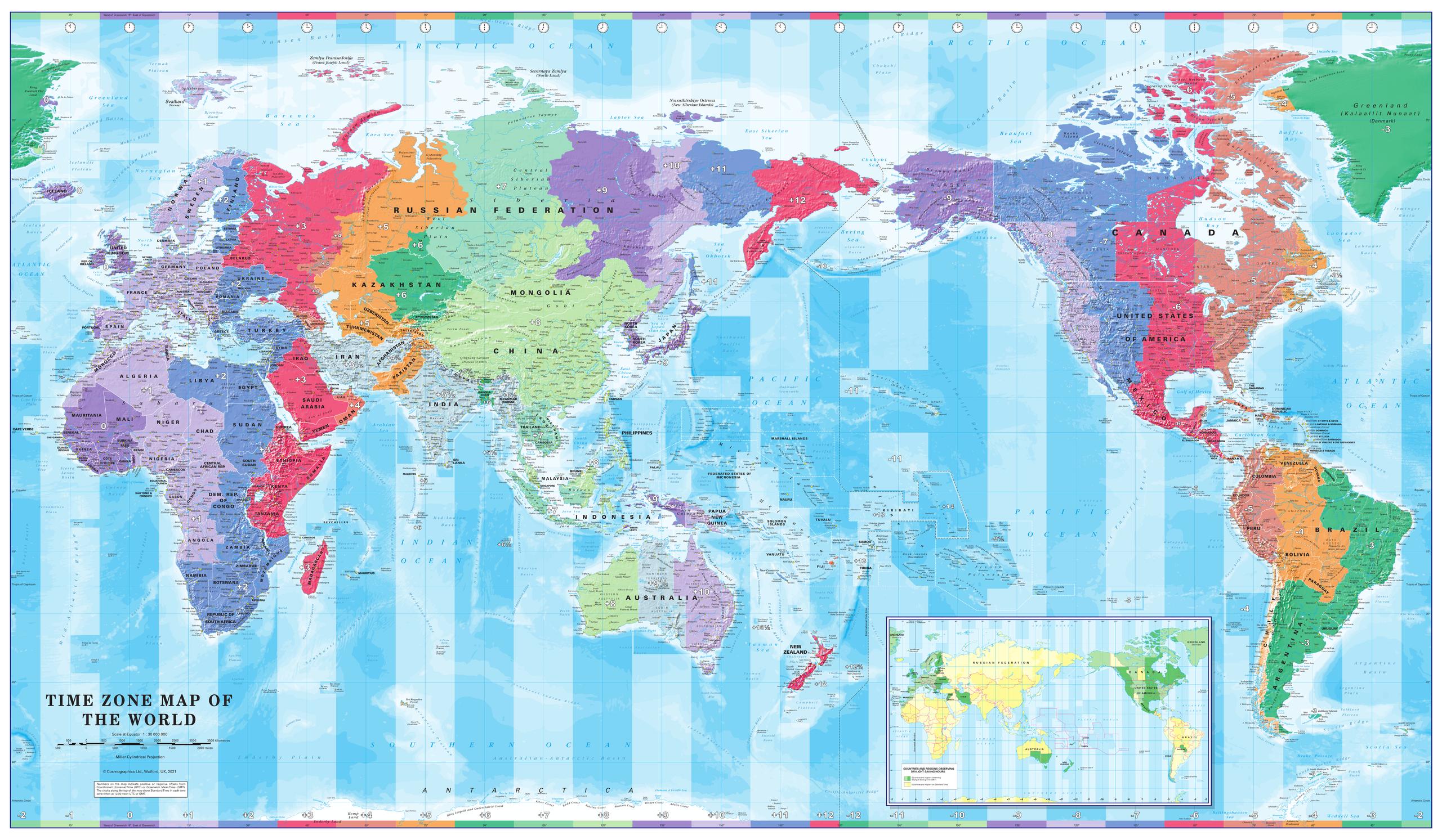
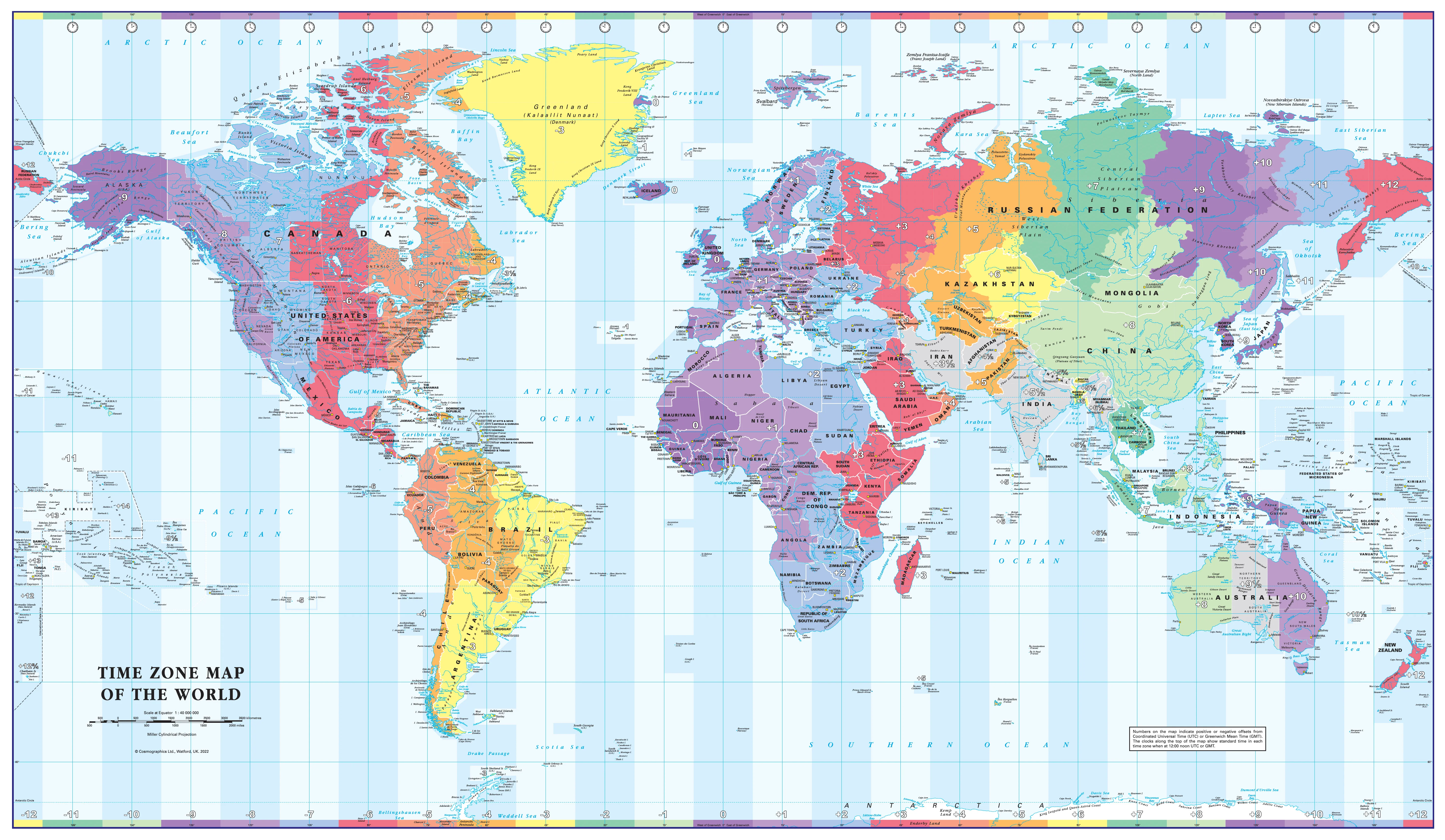
Step into a new perspective of our planet with the Pacific-Centred World Political Map by the National Geographic Society. Presented in traditional blue tones with exceptional cartographic clarity, this map offers a refreshing view of the globe—placing the Pacific Ocean at the centre and shifting the way you see continents, borders, and connections.
Whether for a home study, corporate boardroom, or classroom, this is both an authoritative reference tool and a striking piece of wall décor. Its meticulous detail and premium finish ensure it will inspire curiosity and conversation for years to come.
🗺 A Pacific-Centred Perspective
Most world maps use an Africa-centred projection, but this map offers a different worldview—placing the Pacific Ocean at the heart and highlighting connections across Oceania, Asia, and the Americas. This shift is especially valuable for those focused on Asia-Pacific trade, travel, or cultural geography.
📌 Cartographic Excellence by National Geographic
-
Winkel Tripel Projection: Minimises distortion, ensuring continents retain their true proportions—especially near the poles.
-
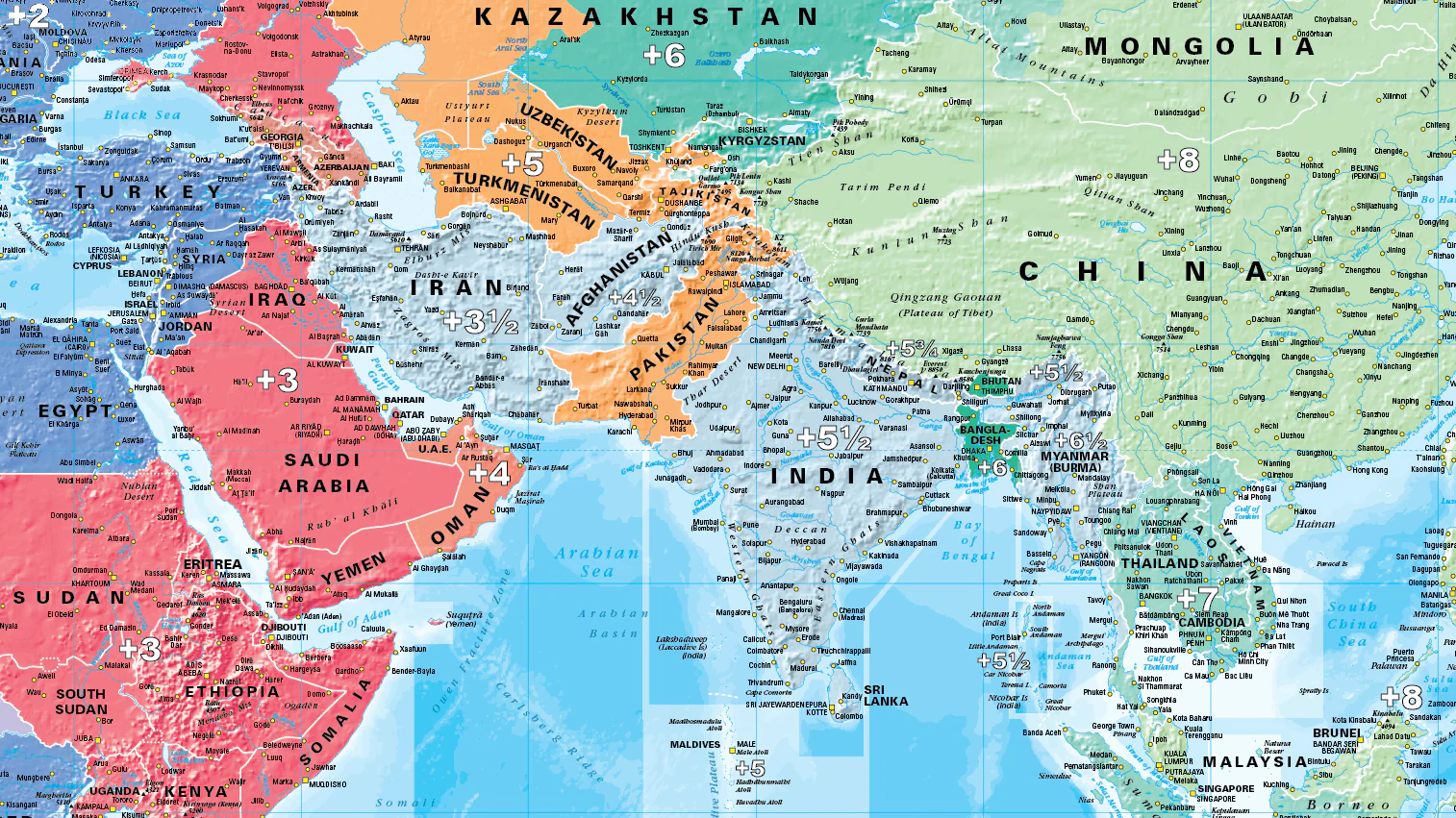
Clear Political Boundaries: Heavy coloured border lines separate nations, while interiors remain white for maximum legibility of place names and political information.
-
Shaded Relief: Mountain ranges and terrain are rendered with subtle 3D shading, adding depth and realism.
-
Oceanography Detail: Depicts ocean depths, currents, and major undersea features.
-
Thematic Insets: Smaller maps in the lower corners show population density, vegetation, and global land use.
🖼 Premium Laminated Finish
-
Durable Encapsulation: True encapsulation between two sheets of 80-micron gloss laminate for long-lasting protection.
-
Markable Surface: Use with dry/wet-erase markers or Mark-It Dots to track travels, projects, or global events.
-
Vivid Colours: Lamination preserves colour vibrancy, resisting fading and wear.
🪵 Wooden Hang Rails – Ready to Display
-
Effortless Hanging: Pre-fitted timber hang rails at the top and bottom, complete with a hanging cord.
-
Natural Timber Finish: Lacquered for elegance, complementing both modern and classic interiors.
-
No Framing Required: The perfect blend of function and style for easy wall display.
Note: Please allow 10 working days for delivery, as hang rails are custom-fitted by our professional framer.
📏 Specifications
| Feature | Details |
|---|---|
| Product Name | World Political Wall Map – Pacific Centred |
| Publisher | National Geographic Society |
| Projection | Winkel Tripel |
| Scale | 1:36,384,000 |
| Map Dimensions | 1100 mm (W) × 780 mm (H) |
| Print Finish | Hard-laminated with 80-micron gloss laminate |
| Hanging | Timber hang rails with cord |
| Delivery Time | 10 working days for hang-railed maps |
| Made In | Australia |
🌟 Why Choose This Map?
-
Unique Pacific-Centred View: Perfect for those who want a fresh perspective on global geography.
-
Educational & Decorative: Equally suited for teaching, planning, and inspiring wanderlust.
-
National Geographic Quality: Backed by over a century of cartographic expertise.
-
Ready to Hang: No additional framing required—beautiful, practical, and professional.
Shift your view of the world
The Pacific-Centred World Political Wall Map is more than a reference—it’s an invitation to see global connections differently. Perfect for classrooms, offices, and travel enthusiasts, it combines stunning design with unmatched accuracy.
Order today and enjoy a world-class map that is as informative as it is beautiful.
Original: $269.95
-70%$269.95
$80.98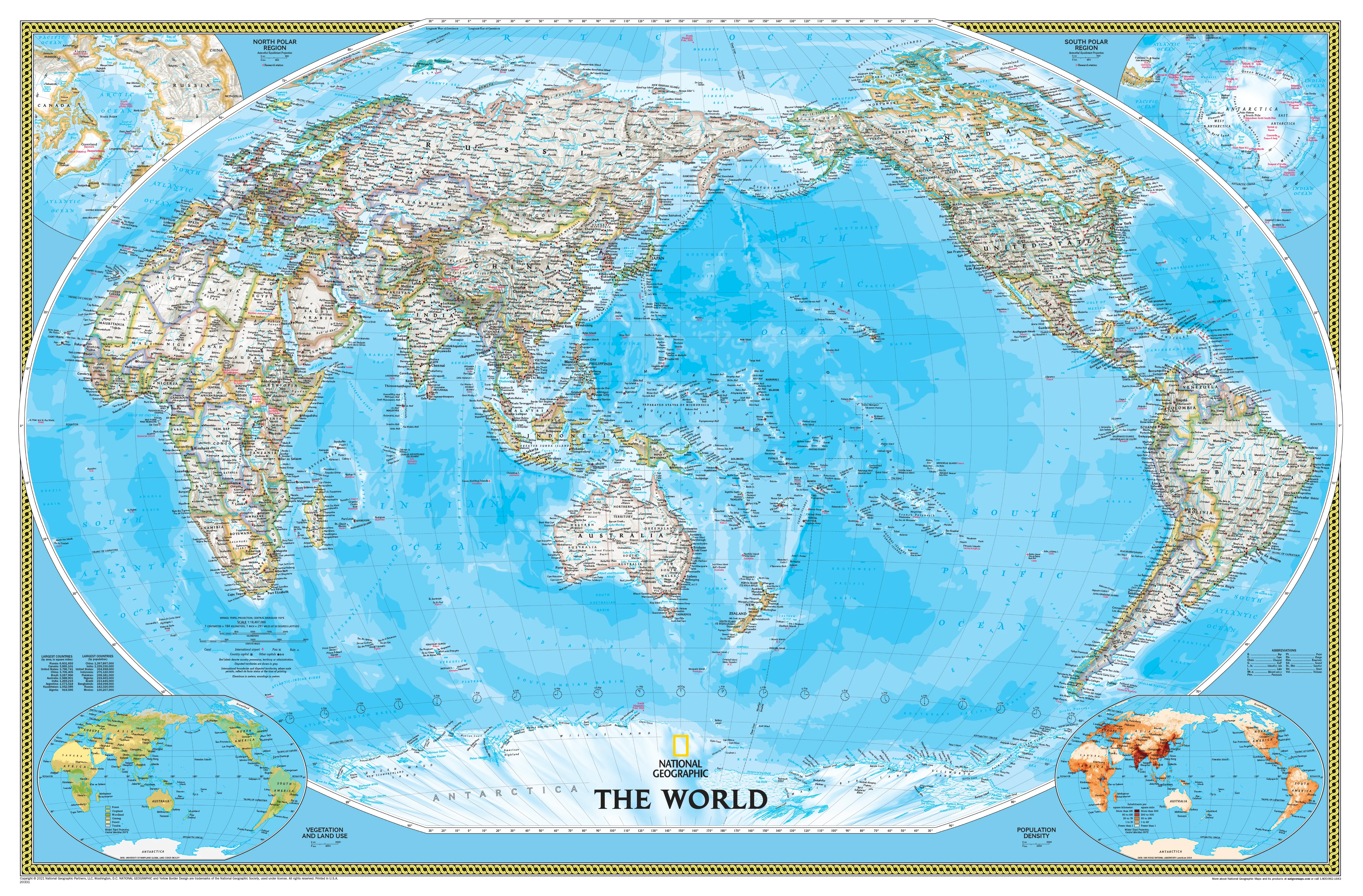
Description
🌏 World Political Wall Map – Pacific Centred
By National Geographic – Laminated with Wooden Hang Rails
Size: 1100 mm (W) × 780 mm (H) | Scale: 1:36,384,000
Step into a new perspective of our planet with the Pacific-Centred World Political Map by the National Geographic Society. Presented in traditional blue tones with exceptional cartographic clarity, this map offers a refreshing view of the globe—placing the Pacific Ocean at the centre and shifting the way you see continents, borders, and connections.
Whether for a home study, corporate boardroom, or classroom, this is both an authoritative reference tool and a striking piece of wall décor. Its meticulous detail and premium finish ensure it will inspire curiosity and conversation for years to come.
🗺 A Pacific-Centred Perspective
Most world maps use an Africa-centred projection, but this map offers a different worldview—placing the Pacific Ocean at the heart and highlighting connections across Oceania, Asia, and the Americas. This shift is especially valuable for those focused on Asia-Pacific trade, travel, or cultural geography.
📌 Cartographic Excellence by National Geographic
-
Winkel Tripel Projection: Minimises distortion, ensuring continents retain their true proportions—especially near the poles.
-
Clear Political Boundaries: Heavy coloured border lines separate nations, while interiors remain white for maximum legibility of place names and political information.
-
Shaded Relief: Mountain ranges and terrain are rendered with subtle 3D shading, adding depth and realism.
-
Oceanography Detail: Depicts ocean depths, currents, and major undersea features.
-
Thematic Insets: Smaller maps in the lower corners show population density, vegetation, and global land use.
🖼 Premium Laminated Finish
-
Durable Encapsulation: True encapsulation between two sheets of 80-micron gloss laminate for long-lasting protection.
-
Markable Surface: Use with dry/wet-erase markers or Mark-It Dots to track travels, projects, or global events.
-
Vivid Colours: Lamination preserves colour vibrancy, resisting fading and wear.
🪵 Wooden Hang Rails – Ready to Display
-
Effortless Hanging: Pre-fitted timber hang rails at the top and bottom, complete with a hanging cord.
-
Natural Timber Finish: Lacquered for elegance, complementing both modern and classic interiors.
-
No Framing Required: The perfect blend of function and style for easy wall display.
Note: Please allow 10 working days for delivery, as hang rails are custom-fitted by our professional framer.
📏 Specifications
| Feature | Details |
|---|---|
| Product Name | World Political Wall Map – Pacific Centred |
| Publisher | National Geographic Society |
| Projection | Winkel Tripel |
| Scale | 1:36,384,000 |
| Map Dimensions | 1100 mm (W) × 780 mm (H) |
| Print Finish | Hard-laminated with 80-micron gloss laminate |
| Hanging | Timber hang rails with cord |
| Delivery Time | 10 working days for hang-railed maps |
| Made In | Australia |
🌟 Why Choose This Map?
-
Unique Pacific-Centred View: Perfect for those who want a fresh perspective on global geography.
-
Educational & Decorative: Equally suited for teaching, planning, and inspiring wanderlust.
-
National Geographic Quality: Backed by over a century of cartographic expertise.
-
Ready to Hang: No additional framing required—beautiful, practical, and professional.
Shift your view of the world
The Pacific-Centred World Political Wall Map is more than a reference—it’s an invitation to see global connections differently. Perfect for classrooms, offices, and travel enthusiasts, it combines stunning design with unmatched accuracy.
Order today and enjoy a world-class map that is as informative as it is beautiful.