World Political (Australia Centred) Wall Map published 1944
A Unique WWII-Era Perspective of the World
🗺️ Published by Universal Business Directories, 1944 | Size: 900 mm (W) x 730 mm (H)
🇦🇺 Proudly Made in Australia
✨ A Striking Snapshot of Wartime Australia
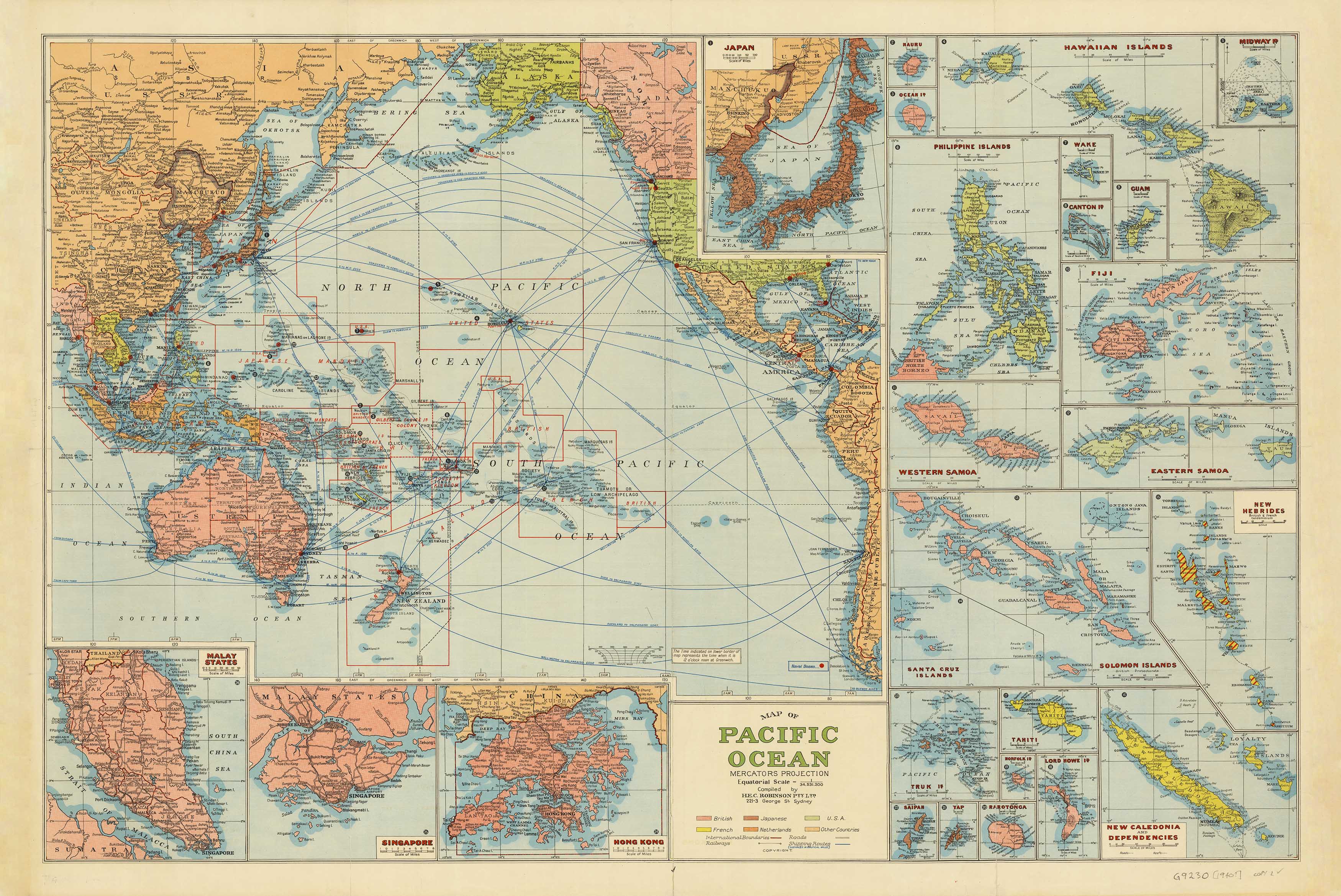
Step back into a pivotal moment in world history with this captivating Australia-centred Mercator projection published in 1944, during the height of the Second World War. Issued by Universal Business Directories, this map places Australia at the heart of global affairs, visually reinforcing the country’s strategic and emotional role in the Pacific theatre.
Rendered in period-accurate colours and tones, the map distinctly shows:
-
🇯🇵 Japanese and German-controlled territories
-
⚓ Japanese Naval Bases, a sobering reminder of regional threat
-
🇬🇧 The British Empire in pink, proudly showing the nation's imperial ties
Beneath the map lies a wartime calendar for 1944–1945 bearing the hopeful message:
“May these months bring us peace”
Accompanying it is a patriotic advertisement from Pope Products Ltd, celebrating Australian manufacturing efforts — in particular, its production of aircraft bombs for Allied forces — and paying tribute to the men and women behind the war effort.
🔍 A Window Into National Spirit
This map is not just a political reference — it’s a poignant artefact of national unity, resilience, and purpose. Ideal for:
-
🖼️ Collectors of wartime memorabilia
-
🏛️ Museum or gallery-style decor
-
📚 Historians, educators, and WWII researchers
-
🎁 Unique gifts for map lovers or veterans' families
🖨️ Available in Three Premium Finishes
📄 160gsm Matte Art Paper
-
Smooth archival-grade paper
-
Perfect for framing under glass
-
Lightweight and elegant
💧 Encapsulated Gloss Laminate
-
True two-sided encapsulation in 80-micron gloss laminate
-
Wipeable, water-resistant and tear-proof
-
Ideal for high-traffic areas or educational use
-
🪵 Optional timber hang rails available
🖼️ 395gsm HP Matte Canvas
-
Printed using fade-resistant pigment inks
-
Exceptional detail and texture
-
Highly durable and designed to last for decades
-
🪵 Optional timber hang rails available
🪵 Timber Hang Rails – Display Ready
For both laminated and canvas formats, we offer handcrafted timber hang rails:
-
Lacquered natural timber finish
-
Top and bottom rails keep the map taut and stylish
-
Pre-fitted cord for easy hanging
-
Transforms your map into a heritage display piece
⏳ Please allow up to 10 working days for hang-railed versions — assembled to order by our framer.
📐 Product Specifications
| Feature | Details |
|---|---|
| Title | World Political (Australia-Centred) Wall Map |
| Original Publisher | Universal Business Directories |
| Year of Publication | 1944 |
| Projection | Mercator (Pacific-centred) |
| Key Inclusions | Japanese & German-held territories, Naval Bases, Empire in pink |
| Extras | 1944–45 Calendar + Pope Products wartime advertisement |
| Size | 900 mm (W) x 730 mm (H) |
| Material Options | Paper, Laminated, Canvas |
| Hang Rail Option | Available for both Laminated & Canvas formats |
| Made In | Australia |
🎯 Who It's For
-
🧭 Map collectors and military history enthusiasts
-
🇦🇺 Australians seeking historical décor or teaching tools
-
🎓 Academics and libraries showcasing wartime perspectives
-
🏡 Interior designers creating vintage or patriotic focal points
📦 How to Order
-
Choose your preferred material
-
Add optional timber hang rails
-
Add to cart and checkout
-
Receive your map securely packed and ready to admire
This evocative map blends wartime history, imperial geography, and Australian spirit into one stunning presentation. Whether you're honouring the past or decorating with purpose, it's a rare gem from a defining era.
Original: $59.95
-70%$59.95
$17.98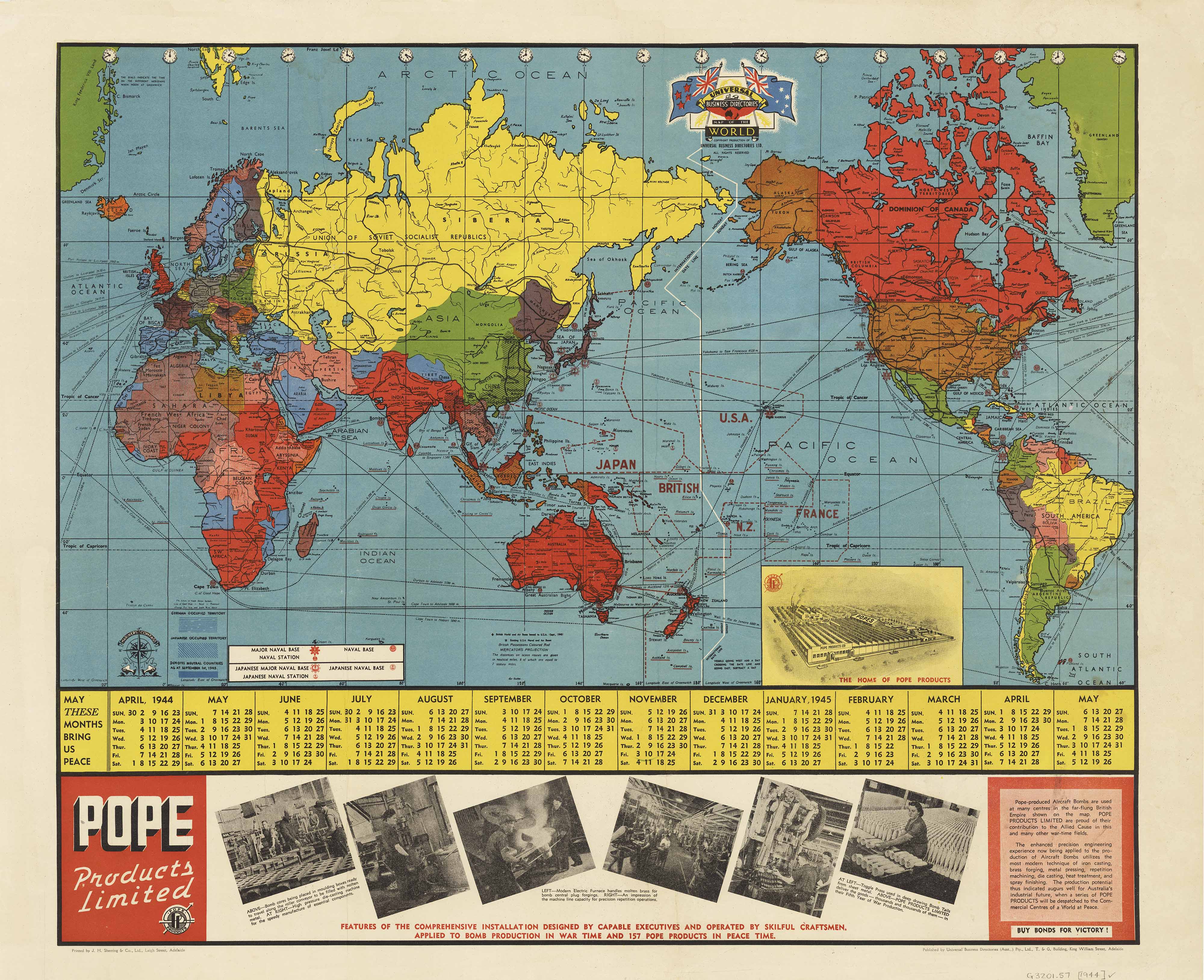
Description
A Unique WWII-Era Perspective of the World
🗺️ Published by Universal Business Directories, 1944 | Size: 900 mm (W) x 730 mm (H)
🇦🇺 Proudly Made in Australia
✨ A Striking Snapshot of Wartime Australia
Step back into a pivotal moment in world history with this captivating Australia-centred Mercator projection published in 1944, during the height of the Second World War. Issued by Universal Business Directories, this map places Australia at the heart of global affairs, visually reinforcing the country’s strategic and emotional role in the Pacific theatre.
Rendered in period-accurate colours and tones, the map distinctly shows:
-
🇯🇵 Japanese and German-controlled territories
-
⚓ Japanese Naval Bases, a sobering reminder of regional threat
-
🇬🇧 The British Empire in pink, proudly showing the nation's imperial ties
Beneath the map lies a wartime calendar for 1944–1945 bearing the hopeful message:
“May these months bring us peace”
Accompanying it is a patriotic advertisement from Pope Products Ltd, celebrating Australian manufacturing efforts — in particular, its production of aircraft bombs for Allied forces — and paying tribute to the men and women behind the war effort.
🔍 A Window Into National Spirit
This map is not just a political reference — it’s a poignant artefact of national unity, resilience, and purpose. Ideal for:
-
🖼️ Collectors of wartime memorabilia
-
🏛️ Museum or gallery-style decor
-
📚 Historians, educators, and WWII researchers
-
🎁 Unique gifts for map lovers or veterans' families
🖨️ Available in Three Premium Finishes
📄 160gsm Matte Art Paper
-
Smooth archival-grade paper
-
Perfect for framing under glass
-
Lightweight and elegant
💧 Encapsulated Gloss Laminate
-
True two-sided encapsulation in 80-micron gloss laminate
-
Wipeable, water-resistant and tear-proof
-
Ideal for high-traffic areas or educational use
-
🪵 Optional timber hang rails available
🖼️ 395gsm HP Matte Canvas
-
Printed using fade-resistant pigment inks
-
Exceptional detail and texture
-
Highly durable and designed to last for decades
-
🪵 Optional timber hang rails available
🪵 Timber Hang Rails – Display Ready
For both laminated and canvas formats, we offer handcrafted timber hang rails:
-
Lacquered natural timber finish
-
Top and bottom rails keep the map taut and stylish
-
Pre-fitted cord for easy hanging
-
Transforms your map into a heritage display piece
⏳ Please allow up to 10 working days for hang-railed versions — assembled to order by our framer.
📐 Product Specifications
| Feature | Details |
|---|---|
| Title | World Political (Australia-Centred) Wall Map |
| Original Publisher | Universal Business Directories |
| Year of Publication | 1944 |
| Projection | Mercator (Pacific-centred) |
| Key Inclusions | Japanese & German-held territories, Naval Bases, Empire in pink |
| Extras | 1944–45 Calendar + Pope Products wartime advertisement |
| Size | 900 mm (W) x 730 mm (H) |
| Material Options | Paper, Laminated, Canvas |
| Hang Rail Option | Available for both Laminated & Canvas formats |
| Made In | Australia |
🎯 Who It's For
-
🧭 Map collectors and military history enthusiasts
-
🇦🇺 Australians seeking historical décor or teaching tools
-
🎓 Academics and libraries showcasing wartime perspectives
-
🏡 Interior designers creating vintage or patriotic focal points
📦 How to Order
-
Choose your preferred material
-
Add optional timber hang rails
-
Add to cart and checkout
-
Receive your map securely packed and ready to admire
This evocative map blends wartime history, imperial geography, and Australian spirit into one stunning presentation. Whether you're honouring the past or decorating with purpose, it's a rare gem from a defining era.