New Zealand Wall Map by John Tallis & Company 1851
Vintage Cartography | Illustrated Borders | Premium Finishes
Step back into the mid-19th century with this exquisite reproduction of John Tallis & Company’s 1851 map of New Zealand — a piece where fine cartography meets Victorian artistry. Renowned for their ornate style, Tallis maps combine accurate geographic detail with beautifully engraved vignettes and elegant decorative borders, making them as much art as they are historical documents.
This map captures New Zealand in a time when European settlement was still developing, providing a fascinating historical perspective while remaining a visually striking centrepiece for any wall.
📜 Historical & Artistic Highlights
-
Victorian-Era Design – Elegant engraved border and period typography.
-
Detailed 1851 Cartography – Shows coastlines, settlements, and key geographic features.
-
Illustrative Vignettes – Charming scenes depicting landscapes, people, and local fauna.
-
Richly Decorative – A perfect blend of geography and artistry, true to the Tallis tradition.
📐 Specifications
| Feature | Detail |
|---|---|
| Title | New Zealand Wall Map – John Tallis & Co., 1851 |
| Original Publisher | John Tallis & Company |
| Year Published | 1851 |
| Reproduction Size | 600 mm (W) x 440 mm (H) |
| Materials | 160 gsm matte-coated paper / 80-micron gloss laminate / 395 gsm HP Matte Canvas |
| Origin | Printed and professionally finished in Australia |
✨ Available Finishes
| Format | Description |
|---|---|
| 🖨️ Paper (160 gsm) | Heavyweight matte-coated paper — ideal for framing under glass. |
| 🧼 Laminated (Encapsulated) | Fully sealed between two sheets of 80-micron gloss laminate. Wipe-clean, tear-resistant, and durable. |
| 🪵 Laminated with Wooden Hang Rails | Laminated map mounted with lacquered timber rails (top & bottom) and a hanging cord — ready to display. |
| 🖼️ Canvas (395 gsm) | HP Professional Matte Canvas printed with archival pigment-based inks — richly textured, fade-resistant, and gallery-quality. |
| 🪵 Canvas with Wooden Hang Rails | Canvas mounted with lacquered timber rails and a hanging cord for a timeless, display-ready look. |
🔨 Please allow up to 10 working days for delivery of hang-railed maps, as each one is professionally mounted by our custom framer.
💡 Why You’ll Love This Map
✔️ Authentic reproduction of a celebrated Victorian mapmaker’s work
✔️ Intricate decorative elements — a statement piece for your wall
✔️ Premium finishes — from archival paper to gallery-grade canvas
✔️ Compact size — ideal for study walls, libraries, or gallery collections
✔️ A captivating conversation piece blending art and history
🎯 Perfect For
-
History Enthusiasts – Explore New Zealand’s past in fine cartographic detail
-
Collectors – Add an iconic Victorian-era map to your collection
-
Interior Decorators – Create a timeless, heritage-inspired focal point
-
Gift Buyers – A thoughtful present for map lovers and history buffs
The New Zealand Wall Map by John Tallis & Company (1851) is more than a map — it’s a work of art, a historical document, and a decorative treasure.
👉 Order now and own a stunning piece of New Zealand’s cartographic history.
Original: $69.95
-70%$69.95
$20.98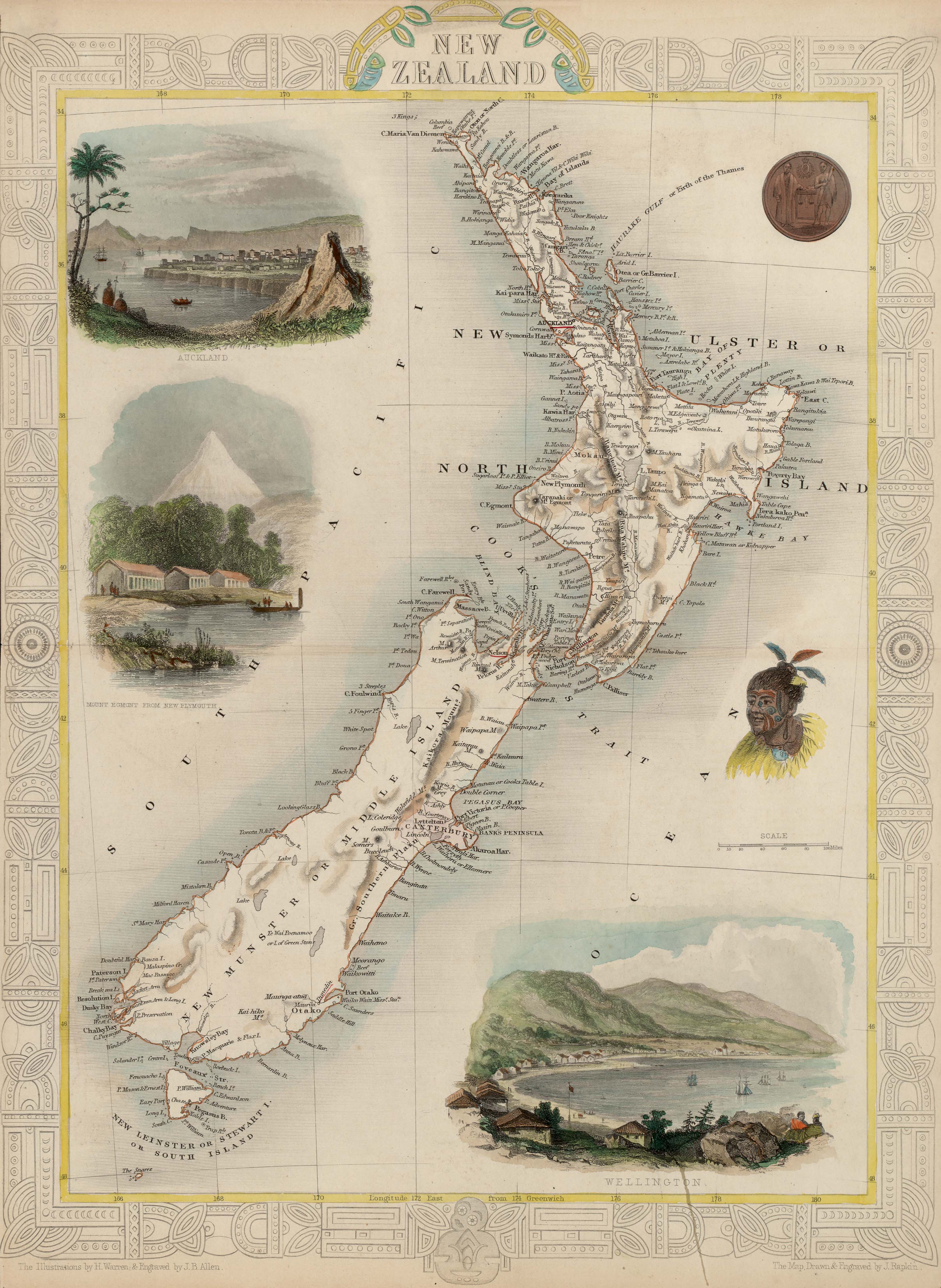
Description
Vintage Cartography | Illustrated Borders | Premium Finishes
Step back into the mid-19th century with this exquisite reproduction of John Tallis & Company’s 1851 map of New Zealand — a piece where fine cartography meets Victorian artistry. Renowned for their ornate style, Tallis maps combine accurate geographic detail with beautifully engraved vignettes and elegant decorative borders, making them as much art as they are historical documents.
This map captures New Zealand in a time when European settlement was still developing, providing a fascinating historical perspective while remaining a visually striking centrepiece for any wall.
📜 Historical & Artistic Highlights
-
Victorian-Era Design – Elegant engraved border and period typography.
-
Detailed 1851 Cartography – Shows coastlines, settlements, and key geographic features.
-
Illustrative Vignettes – Charming scenes depicting landscapes, people, and local fauna.
-
Richly Decorative – A perfect blend of geography and artistry, true to the Tallis tradition.
📐 Specifications
| Feature | Detail |
|---|---|
| Title | New Zealand Wall Map – John Tallis & Co., 1851 |
| Original Publisher | John Tallis & Company |
| Year Published | 1851 |
| Reproduction Size | 600 mm (W) x 440 mm (H) |
| Materials | 160 gsm matte-coated paper / 80-micron gloss laminate / 395 gsm HP Matte Canvas |
| Origin | Printed and professionally finished in Australia |
✨ Available Finishes
| Format | Description |
|---|---|
| 🖨️ Paper (160 gsm) | Heavyweight matte-coated paper — ideal for framing under glass. |
| 🧼 Laminated (Encapsulated) | Fully sealed between two sheets of 80-micron gloss laminate. Wipe-clean, tear-resistant, and durable. |
| 🪵 Laminated with Wooden Hang Rails | Laminated map mounted with lacquered timber rails (top & bottom) and a hanging cord — ready to display. |
| 🖼️ Canvas (395 gsm) | HP Professional Matte Canvas printed with archival pigment-based inks — richly textured, fade-resistant, and gallery-quality. |
| 🪵 Canvas with Wooden Hang Rails | Canvas mounted with lacquered timber rails and a hanging cord for a timeless, display-ready look. |
🔨 Please allow up to 10 working days for delivery of hang-railed maps, as each one is professionally mounted by our custom framer.
💡 Why You’ll Love This Map
✔️ Authentic reproduction of a celebrated Victorian mapmaker’s work
✔️ Intricate decorative elements — a statement piece for your wall
✔️ Premium finishes — from archival paper to gallery-grade canvas
✔️ Compact size — ideal for study walls, libraries, or gallery collections
✔️ A captivating conversation piece blending art and history
🎯 Perfect For
-
History Enthusiasts – Explore New Zealand’s past in fine cartographic detail
-
Collectors – Add an iconic Victorian-era map to your collection
-
Interior Decorators – Create a timeless, heritage-inspired focal point
-
Gift Buyers – A thoughtful present for map lovers and history buffs
The New Zealand Wall Map by John Tallis & Company (1851) is more than a map — it’s a work of art, a historical document, and a decorative treasure.
👉 Order now and own a stunning piece of New Zealand’s cartographic history.